Page 1 of 2
classifier
Posted: Tue Jan 03, 2017 6:00 am
by Bonnie
Hi Daniel, I have been focused on this forum for a long time and learned a lot of things.it’s my first time to ask some questions .I try to use the CANUPO to classify the vegetation、buildings、towers、wires、roads and so on.I have seen the PDF of manual of classifications,but I can’t understand the mean of Scales,and I don’t know how to give the values of scales.I have tried to classify many times,however, The results are all not very well.
My date is from Airborne Ladir.I really want to know how to give the value of scales which is on the dialog of Train classifier.
For example,if I want to classify the tower ,how can I use the CANUPO,and what's the value of scales.
Re: classifier
Posted: Tue Jan 03, 2017 1:20 pm
by Haowyr
Hello Bonnie, if you speak french, I could show you few pages of my MSc thesis, where I "tried" (not sure I succeeded though...) to explain how this part works ;)
Re: classifier
Posted: Tue Jan 03, 2017 7:54 pm
by daniel
CANUPO is powerful to classify things like vegetation, rocks of different size, power lines, etc. It measures a 'dimensionality' (which is roughly how much 1D, 2D or 3D a subset of points is) at various scales (e.g. 1 cm, 10 cm, 20 cm, ... up to 1 m). Then considering how the dimensionality values at all scales, it will be able to differentiate the shapes.
If you want to get good results, you'll need to define your scales well, and you'll also need to give good subsets (e.g. "vegetation" and "non vegetation") to the trainer.
Re: classifier
Posted: Thu Jan 05, 2017 3:01 am
by Bonnie
thanks for your reply,the scales's values are range from 1cm to 1m only?
Re: classifier
Posted: Thu Jan 05, 2017 3:02 am
by Bonnie
Haowyr wrote:Hello Bonnie, if you speak french, I could show you few pages of my MSc thesis, where I "tried" (not sure I succeeded though...) to explain how this part works ;)
it's ok ! you can give me
Re: classifier
Posted: Thu Jan 05, 2017 3:52 am
by Bonnie
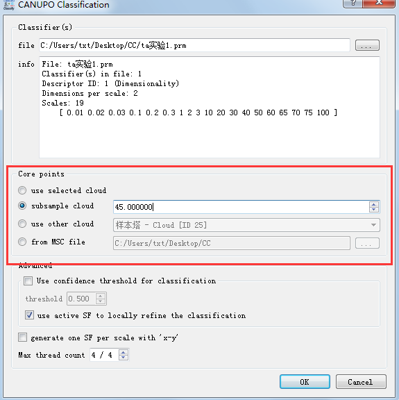
- MN8{JO8%}@LB6~~KWU6)5UW.png (34.95 KiB) Viewed 25380 times
- MN8{JO8%}@LB6~~KWU6)5UW.png (34.95 KiB) Viewed 25380 times
I feel the result of classification training well from the dialog of CANUPO training and the Statistics.
And use this .prm,what's the meaning of the Core points on the dialog of CANUPO Classification.
The result of classification is not good.
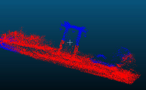
- ZJT9AS08C_`WA5%66}7GJP9.png (26.37 KiB) Viewed 25380 times
Re: classifier
Posted: Thu Jan 05, 2017 7:47 am
by daniel
@Bonnie: no, the '1 cm - 1m' range was only an example. It depends on your cloud units AND on the objects scale! If what I see on your screen capture is an electric pylon, then the scale is probably much bigger.
Re: classifier
Posted: Thu Jan 05, 2017 7:51 am
by Haowyr
https://fr.scribd.com/document/33574590 ... rrDumW81E0
Imo, the easiest way to explain the scale is "how close from the object you look at it and what general shape it has from it". When you have a scale of 5cm, you take a 5cm sphere part of the cloud and check if it looks like a line, a plane or something in 3D.
Re: classifier
Posted: Fri Jan 06, 2017 8:18 am
by Bonnie
@ daniel:The terrain of mountain is very complex, the elevation is very difference too,And there are many high trees and vegetation,i have trid many times ,can i really get good result?
Sorry to bother you again and thank you
Re: classifier
Posted: Fri Jan 06, 2017 8:48 am
by daniel
I don't think the terrain is the problem (I have seen very complex scenes properly segmented). Generally the issue is more with the data. You need dense LIDAR point clouds such as TLS scans. I'm not sure an airborne scan is dense enough.
Don't hesitate to send me a cloud sample if you want me to try (cloudcompare [at] danielgm.net).