Page 3 of 3
Re: DEM
Posted: Thu Nov 02, 2017 12:43 am
by Sile
These are my trees that I have projected. The lowest point of each tree are at the same level (Z coordinate), but the points that make up the tree have been stretched in the Z direction. I believe all my settings are correct. I will have to play with it some more. I was just wondering if you have seen this problem before?
Re: DEM
Posted: Thu Nov 02, 2017 6:11 pm
by daniel
Nope, never. The stretching is really suspicious.
Re: DEM
Posted: Fri Nov 10, 2017 6:02 am
by wpqjbzwm
hi, Sile. You may try plugin CSF to get ground and non-ground points, and then use the method provided by Daniel. You can refer to our post at Researchgate:
How to calculate AGL (above ground level) height using CSF in Cloudcompare
Re: DEM
Posted: Wed Nov 15, 2017 4:21 pm
by Sile
Hello wpqjbzwm,
I have used the plugin CSF. Separating the ground points and non-ground points is not the issue. As you can see in my other posts, the issue is my trees are being stretched. When I view the "side view" there are multiple sections of points on a z coordinate. All of these are put together resulting in my stretch tree.
Re: DEM
Posted: Wed Nov 15, 2017 8:15 pm
by daniel
I still don't see how this is possible... are you sure the cloud vertical dimension is right (i.e. parallel to Z)?
If you can't send me the dataset, could you maybe make a video of your process so that we could spot a potential mistake?
Re: DEM
Posted: Thu Nov 16, 2017 2:27 pm
by Sile
Daniel,
I will ask my professor if that is alright to do, since it is not my data. If he agrees, I will be able to post the video tomorrow.
Re: DEM
Posted: Thu Nov 16, 2017 3:38 pm
by Sile
My professor has allowed me to share a sub sample plot of the data with you. How do you want me to send it to you?
Re: DEM
Posted: Thu Nov 16, 2017 5:45 pm
by daniel
You can send me the data directly by email or via a file sharing website (dropbox, google drive, etc.) : cloudcompare [at] danielgm.net
Re: DEM
Posted: Fri Nov 17, 2017 7:48 am
by daniel
Thanks for the dataset.
I tested the method I described earlier and I couldn't reproduce your result:
- load the cloud
- start the Rasterize tool
- make sure the projection direction is 'Z'
- set the grid 'step' to something not too small (I used 0.1 or 0.2 during my tests)
- make sure the 'height range' checkbox in the 'Export' section is checked
- click on the 'Cloud' button in the same 'Export' section
- close the Rasterize tool
- select the generated 'raster' (cloud)
- change the active scalar field to 'Height range' (see the cloud properties)
- call 'Edit > Scalar fields > Set SF as coordinates'
- click on the 'magnifier' icon to center the camera on the cloud (as its coordinates may have changed a lot)
Here's what I get:
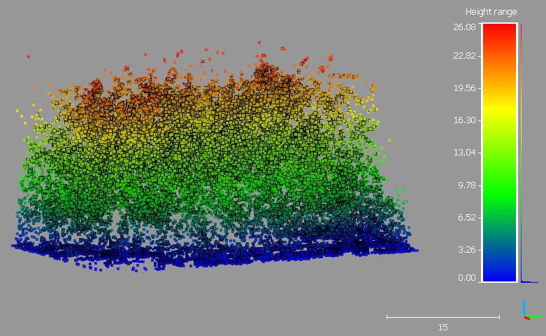
- cc_height_range.JPG (91.98 KiB) Viewed 9410 times
Re: DEM
Posted: Mon Nov 20, 2017 12:24 pm
by Sile
Daniel,
That worked perfectly. The problem I believe I was having was not having the correct Active field selected. Thank you so much for working with me on this problem and I hope others find it useful as well. Cheers!