qCANUPO (classifier files, etc.)
Re: qCANUPO (classifier files, etc.)
You should take a look at the documentation (https://www.cloudcompare.org/doc/wiki/i ... O_(plugin)). But you'd better read the CANUPO article to really understand everything...
Daniel, CloudCompare admin
Re: qCANUPO (classifier files, etc.)
I read it! But I can´t found where is the article of CANUPO.
Re: qCANUPO (classifier files, etc.)
There's a link at the beginning of the wiki page: http://nicolas.brodu.net/common/recherc ... canupo.pdf
Daniel, CloudCompare admin
Re: qCANUPO (classifier files, etc.)
Hi,
I'm currently working as an intern at a University where I have been asked to summarize CANUPO and make it understandable for everybody without them having to go trough different publications. Together with the summation I'm applying the classifier to a large research field in the Alps.
After a lot of reading and trying to understand the classifier I have come across some questions.
My first question is pretty straight forward. Does this classifier work on dense point clouds that come from Agisoft ? There are 3000+ pictures over several days, made with the help of a drone that we 'stitch' together (see photogrammetry) (to make al long story short). Out of that I generated a point cloud covering the whole area ending up with a very dens cloud of over 300,000,000 points.
Is the coverage linear enough to use the CANUPO scaling or will the different photo's result in different densities, therefor not recognizing similar surfaces ?
I do have a single terrestrial LIDAR scan (but this is much less dense, +18,000,000) and has a lot of shadow effect. Also in this Lidar scan there is no RGB context to train a classifiër.
Second:
This is probably a very basic question , but i haven't really come across a clear answer or maybe i looked over it. But how do i practically train a classifier ? I would take a small piece out of the huge terrain for a start. Here is where I have tried many things, but I have yet to find a proper solution:
There are two 'scales' that need input -->
Scale 1:
Now before I go to far, do i cut out all the (for ex.) vegetation, or just a sample ?
Then up next I know I need to merge what I have cut out together with what was left.
So that woud be my first scale. Am I right up to now ?
Scale 2:
Do I just put the whole piece here ? My understanding is that this way it has a way of distinguishing the 2 parts out of scale 1?
Or do I repeat what I did in 'Scale 1'. I should choose another part I want to classify (for ex. big boulders) and after I cut it out and merge it, put it where scale 2 is ?
What am I doing wrong, where are my mistakes, should I read some more papers ( I have read the one from N. Brodu and D. Lague about 3d terrestrial lidar data classification of complex natural scenes... / and the one also from N. Brudo and D. Lague about classification of point clouds using the CANUPO software suit v1.2 (april 2013) )
PS: If needed I would gladly show a render of the site so that it is easier to visualize.
-
lightcuber
- Posts: 6
- Joined: Tue Feb 04, 2020 6:52 pm
Re: qCANUPO (classifier files, etc.)
Hi Simon,
I have a few comments. First I'm also doing research on classifying mountain terrain point clouds so it might be useful for us to get in touch. (send me a note on ResearchGate https://www.researchgate.net/profile/Luke_Weidner)
For your first question: in principle CANUPO should work on photogrammetry point clouds, but not great in my experience because photogrammetry point clouds are often "smoother" than lidar, therefore there is less geometric contrast between vegetation and other objects. So you will probably get better results incorporating the point color into the classification.
For your second question it's not entirely clear to me. For training you need to make two point clouds, one that only contains the first class, and one that only contains the second class. Again feel free to reach out to me on ResearchGate and perhaps I can help out, I've also got a couple of papers on there related to this topic.
Luke
-
AurélieGuil
- Posts: 1
- Joined: Tue Oct 13, 2020 8:52 am
Re: qCANUPO (classifier files, etc.)
Bonjour,
j'ai un nuage de points que je souhaiterai classifié en plusieurs classes : routes, végétation, bâtiments, murs...
J'essaye d'utiliser Canupo, j'ai créé toutes mes classes en nuages de points isolés comme expliquer dans le tuto Wiki.
J'ai pu enregistrer un premier fichier de classification prm avec 2 de mes classes.
J'ai lancer un test : résultat mon nuage se colorise en 2 couleurs : rouge et bleu mais n'a pas "reconnu" les éléments appartenant à mes classes, à savoir, route et végétation.
Je ne comprend pas trop comment utiliser CANUPO.
Comment créer un fichier prm avec plus de 2 classes dedans?
Comment puis-je faire pour classifier mon nuage de points avec toutes mes classes ?
Et surtout s'il y a du nuage de points qui n'appartient à aucune classe comment cela réagit?
Peut-être que j'en demande trop au plug-in !
Merci pour vos réponses
Aurélie
Re: qCANUPO (classifier files, etc.)
Il me semble qu'il y a une section de ce forum "French only" ;)
Mais rapidement : Canupo est "binaire". Il sépare un nuage en deux. Il faut donc avoir une stratégie en cascade :
1) Classificateur végétation / tout le reste
2) Classificateur à appliquer à "tout le reste" : bâtiments / routes + etc.
3) Classificateur à appliquer à "routes + etc." : routes / etc.
4) ...
Daniel, CloudCompare admin
Re: qCANUPO (classifier files, etc.)
Hi,
Excuse me for coming back this late, it has been a while since i touched CloudCompare.
I found this youtube link in 2020 that helped me a lot to understand basic CANUPO. The paper from N. Brudo and D. Lague about classification of point clouds using the CANUPO software suit v1.2 is much clearer to me after watching this:
https://www.youtube.com/watch?v=XF41Qj4zaVg&t=3094s
Simon
Re: qCANUPO (classifier files, etc.)
Hi there friends of point clouds,
first of all thank you for this amazing software. I just started working with CloudCompare and enjoy it. But I have some questions about it, especially about classification.
Thank you Simon for the link:)
There is a .las-file of my hometown Cologne, Germany, which you can download from this link.
https://www.opengeodata.nrw.de/produkte/
I have some problems to get good classification results. This is what I did.
1) Open file
2) clone the file a few times, because there is unfortunately no "go back"-button
3) extract Z-coordinates "Tools --> Projection --> Export coordinates to SF
4) I want to classifiy buildings, therefore I segment a couple of buildings out from the imported file
5) Train both classes, the buildings against the remaining point cloud of the city
Point 5) is now my issue. How do choose the parameters such as Scales. Scales are the diameters of that so called neighborhood ball, that goes through the selected pointcloud in the classifier, right?
The box dimension of city point cloud is X=471m, Y=600m and Z=82m and for the point clouds of only buildings is X=285m, Y=568m, Z=38m
How do I choose the scale ramp in the train classifier window accurately?
Do I have to choose the original cloud for descriptors? If yes, which cloud? The original not-segmented cloud?
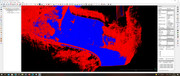
6) After training I get the results which you can see attached here. For a good result blue and red points should be actually separated accurately, right?
I know this is a lot for the beginning but you would help me a lot. Thank you very much:)
Cheers
Altan
first of all thank you for this amazing software. I just started working with CloudCompare and enjoy it. But I have some questions about it, especially about classification.
Thank you Simon for the link:)
There is a .las-file of my hometown Cologne, Germany, which you can download from this link.
https://www.opengeodata.nrw.de/produkte/
I have some problems to get good classification results. This is what I did.
1) Open file
2) clone the file a few times, because there is unfortunately no "go back"-button
3) extract Z-coordinates "Tools --> Projection --> Export coordinates to SF
4) I want to classifiy buildings, therefore I segment a couple of buildings out from the imported file
5) Train both classes, the buildings against the remaining point cloud of the city
Point 5) is now my issue. How do choose the parameters such as Scales. Scales are the diameters of that so called neighborhood ball, that goes through the selected pointcloud in the classifier, right?
The box dimension of city point cloud is X=471m, Y=600m and Z=82m and for the point clouds of only buildings is X=285m, Y=568m, Z=38m
How do I choose the scale ramp in the train classifier window accurately?
Do I have to choose the original cloud for descriptors? If yes, which cloud? The original not-segmented cloud?
6) After training I get the results which you can see attached here. For a good result blue and red points should be actually separated accurately, right?
I know this is a lot for the beginning but you would help me a lot. Thank you very much:)
Cheers
Altan
-
PablerasBCN
- Posts: 284
- Joined: Sat Jan 20, 2018 1:57 pm
Re: qCANUPO (classifier files, etc.)
Hi there,
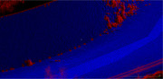
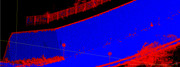
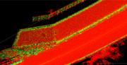
I've been able to train the classifier, ti does an spectacular Job separating the road and nearby walls from the rest of the data on a mobile mapping dataset.
I've noticed tho, tha tat the edges of the dataset and at the edges of the structures, the classifier seems to get confused and I wonder if there is anything I could do to improve the classification.
.
conficence: